

Archive position — measured, not model output
0 likes on Devpost
2,263 of the 7,850 archived projects have more likes, and 5,587 share exactly 0 — so this project's #6,496 place in the like-ranked listing is a tie-break inside that group, not a ranking.
Projects (log scale)
Likes on Devpost. ▲ marks this project's group.
Show the figures
| Likes | Projects | Share of archive |
|---|---|---|
| 0 | 5,587 | 71.2% |
| 1 | 1,758 | 22.4% |
| 2 | 284 | 3.6% |
| 3–4 | 132 | 1.7% |
| 5–9 | 75 | 1.0% |
| 10+ | 14 | 0.2% |
 User Stories BotA demo video on every pull request
Get a demo video on every new feature
GitHub App that watches your pull requests and records a narrated, captioned demo.
Save time on demo prep and make informed decisions faster with a video walkthrough of every new feature.
Executive Summary
What the company appears to be
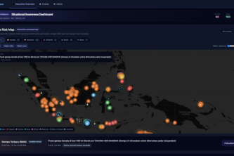
SadarBencana.id is a self-reported real-time disaster intelligence dashboard built as a hackathon project by one developer (Joko Setiyadi). It aggregates and visualizes disaster-related data from multiple sources including government agencies, scientific platforms, news outlets, and weather services. The platform presents this information through interactive maps, timelines, alerts, and risk lists, with capabilities for user-defined monitoring zones and indicative loss estimates for insurance use cases.
What changed
This is a new project submitted to the OpenAI 2026 hackathon. No prior version or commercial history is evidenced.
Single most important open question
Is there any evidence of actual deployment, users, revenue, or traction beyond the author's self-reported description?
What The Product Actually Is
The description states that SadarBencana.id is a "real-time disaster intelligence dashboard" that collects and organizes disaster information from multiple sources including BMKG, USGS, NASA FIRMS, GDACS, PetaBencana, GVP, and trusted news providers.
It provides:
- An interactive risk map for earthquakes, wildfires, floods, volcanic activity, and geolocated news
- A unified timeline combining disaster events, news signals, and operational alerts
- Event filtering by magnitude, source, location, category, and time range
- Risk classification using Low, Moderate, High, and Critical severity levels
- Multi-source corroboration for verifying disaster information
- An acknowledgement workflow for operational triage
- Source-health monitoring to identify stale, unavailable, or failing data connectors
- Direct access to weather maps, official monitoring channels, and emergency information
- Executive indicators for active events, maximum magnitude, open alerts, and hazard distribution
- User-defined monitoring zones based on selected locations
- Risk lists generated from threats detected within or near each monitoring zone
- Alerts when a disaster may affect a user's monitored area
- Detailed information about the disaster type, severity, location, distance, occurrence time, and official source
- Exposure monitoring and indicative loss estimates for insurance and reinsurance companies
The system is described as modular, web-based, and designed with responsive dashboard elements.
Evidence Self-reported by author. No independent verification or demonstration provided.
Positioning & Claim Evolution
The description states that SadarBencana.id was built to address fragmented disaster information across government agencies, scientific platforms, news outlets, social media, and weather services. The platform aims to help decision-makers open multiple websites and manually determine which information is current, relevant, and reliable.
Positioning:
- A unified situational-awareness workspace for disaster events
- Helps users detect risks, prioritize incidents, and support rapid emergency decisions
- Targets disaster-response teams, risk analysts, insurance and reinsurance companies, businesses, and the general public
The author claims the platform transforms fragmented information into actionable situational awareness and risk intelligence.
Evidence Self-reported by author. No external validation or market positioning data provided.
Target Customer & ICP
The description states that SadarBencana.id targets:
- Disaster-response teams
- Risk analysts
- Insurance and reinsurance companies
- Businesses
- General public
For the general public, monitoring zones provide relevant disaster information for locations such as homes, workplaces, family residences, or other areas they want to monitor.
For insurance and reinsurance companies, monitoring zones can be connected to insured portfolios or exposure data. The system can then identify potentially affected assets, risk concentrations, and indicative loss estimates when a disaster occurs.
Evidence Self-reported by author. No evidence of actual customer base or segmentation beyond stated claims.
Business Model & Pricing Evidence
The description does not provide any information about pricing, monetization strategy, or business model.
Evidence Not evidenced.
Technical & Delivery Signals
Built with:
- Caddy
- Docker
- Golang
- Mastra-AI
- Python
- React
- Redis
- Supabase
The platform is described as modular and web-based. Data-ingestion services collect information from multiple APIs and feeds, normalize different data formats, remove duplicates, classify events, and enrich them with geographic information.
Processed data is presented through a responsive dashboard containing interactive maps, event tables, alert cards, timelines, filters, risk lists, and source-health indicators.
Automatic refresh mechanisms keep the operational view up to date.
Geospatial matching compares disaster locations with user-defined monitoring zones. When an event occurs within or may affect a selected zone, the system adds it to the relevant risk list and generates a prioritized alert.
For insurance use cases, risk zones can be connected to portfolio and exposure values to produce indicative loss estimates.
Evidence Self-reported by author. No evidence of actual deployment, performance metrics, or technical architecture details beyond stated tools.
Traction & Maturity Signals
The description states that this is a hackathon project submitted to the OpenAI 2026 hackathon. There is no evidence of:
- Revenue
- Customers
- Users
- Product-market fit
- Commercial traction
- Deployment history
- Operational metrics
Evidence Not evidenced.
Competitive Context
The description does not provide any information about competitive landscape or existing alternatives.
Evidence Not evidenced.
Open Questions & Risks
- Unverified claims: All features and capabilities are self-reported without independent verification.
- No traction evidence: No revenue, customers, or usage data provided.
- Single-person team: Only one developer is mentioned; no indication of team size or expansion plans.
- Hackathon project: This is a hackathon submission with no known commercial evolution.
- Data reliability concerns: The platform claims to aggregate data from multiple sources but does not describe how it handles inconsistencies, accuracy issues, or source credibility.
- Lack of clarity on operational use: While the author describes intended use cases, there's no evidence that these have been tested in real-world scenarios.
- Ambiguity around loss estimation: The description notes that indicative loss estimates are not final claim values but does not clarify how they might be used operationally.
Evidence Inferred from self-reported claims and absence of supporting data.
Questions the description leaves open
- What is the actual source of the data being collected? How do you verify its accuracy?
- Have you tested the platform with any real users or stakeholders in disaster response?
- What are your plans for scaling beyond a single developer?
- Are there any existing partnerships or collaborations with disaster management agencies or insurance companies?
- How do you plan to monetize this product if at all?
- What is the current status of the platform? Is it deployed, and if so, where?
- How do you handle data privacy and compliance issues related to emergency information?
- What are the technical challenges you've faced in integrating different data sources?
- Do you have any plans for expanding beyond Indonesia's disaster landscape?
- How do you ensure that your platform doesn't mislead users by presenting unverified information as authoritative?
Overall Assessment
Confidence Level Low
This is a self-reported hackathon project with no evidence of commercial traction, revenue, customers, or operational deployment. The author describes ambitious capabilities but provides no independent validation or demonstration.
The platform appears to be conceptual and experimental in nature, built as part of a competition rather than a commercial venture.
Assessment Not ready for investment or partnership consideration based on available information. Any potential value would depend heavily on future development, user adoption, and verification of claims made by the author.
Evidence Self-reported only; no third-party validation or operational data provided.
User Stories BotA demo video on every pull request
Get a demo video on every new feature
GitHub App that watches your pull requests and records a narrated, captioned demo.
Save time on demo prep and make informed decisions faster with a video walkthrough of every new feature.
Source
Submitted to the OpenAI 2026 hackathon on Devpost. Project home on Devpost. Back to the full gallery on Devpost.
This competitive analysis was produced by top-founders.com (opens in a new tab)
Generated by a language model from this project's public Devpost page — its tagline, the author's own write-up and any built-with tags listed there — as captured in August 2026. Short quotations are the author's words. It is an opinion on the idea as a business, not on the people behind it, and it reflects the description as published then. If the project has moved on, request a correction below. The analysis is not independent research and contains no verified traction, revenue or customer data.
An independent guide by KFG International LLC — not affiliated with, endorsed by, or connected to Devpost or OpenAI.