

Archive position — measured, not model output
0 likes on Devpost
2,263 of the 7,850 archived projects have more likes, and 5,587 share exactly 0 — so this project's #7,815 place in the like-ranked listing is a tie-break inside that group, not a ranking.
Projects (log scale)
Likes on Devpost. ▲ marks this project's group.
Show the figures
| Likes | Projects | Share of archive |
|---|---|---|
| 0 | 5,587 | 71.2% |
| 1 | 1,758 | 22.4% |
| 2 | 284 | 3.6% |
| 3–4 | 132 | 1.7% |
| 5–9 | 75 | 1.0% |
| 10+ | 14 | 0.2% |
 User Stories BotA demo video on every pull request
Get a demo video on every new feature
GitHub App that watches your pull requests and records a narrated, captioned demo.
Save time on demo prep and make informed decisions faster with a video walkthrough of every new feature.
Executive Summary
What the company appears to be
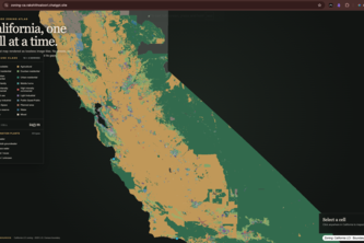
zoning-ca is a self-reported mapping tool that aggregates California’s fragmented zoning data and overlays it with desalination plant locations to help identify potentially suitable sites for industrial caustic soda production from brine. It is described as a single-user project built during a hackathon, using OpenAI's Codex for development.
What changed
The author states they built this tool in response to the challenge of combining scattered datasets—zoning and desalination infrastructure—to support an industrial planning question. The tool reduces a large-scale geographic problem into a manageable map-based interface.
Single most important open question
Is there any evidence that this project has traction, revenue, or adoption beyond its author’s own use? The description does not indicate any commercial activity, customer base, or monetization strategy.
What The Product Actually Is
The description states that zoning-ca is a map-based tool that:
- Converts California’s statewide zoning dataset into a raster grid of ~250-meter cells.
- Plots desalination plants on the same map and allows filtering by water source.
- Enables users to scan for industrially zoned areas, solar-capable land, and proximity to desalination facilities.
- Uses React, Next.js, TypeScript, MapLibre GL, and GeoJSON for rendering.
It is described as a screening tool, not a permit-ready site locator. The author notes that the tool does not replace local verification but aims to reduce a large geographic problem into a tractable set of candidate locations.
Inference The product is a geospatial visualization platform built for industrial planning, with no indication of commercial or monetized use.
Positioning & Claim Evolution
The author positions zoning-ca as:
- A tool that connects land-use planning to industrial resource recovery.
- A first-cut screening mechanism for locating potential caustic soda plants.
- A reproducible foundation for future expansion into a full suitability model.
It is described as a hackathon project, not a commercial product. The author does not claim it is used by any organization or has moved beyond the prototype stage.
Inference The positioning is exploratory and research-oriented, with no evidence of market traction, branding, or commercial intent.
Target Customer & ICP
The description states that zoning-ca is intended for users who are:
- Interested in identifying suitable locations for industrial chemical production.
- Working with desalination brine as a resource.
- Looking to screen large geographic areas for zoning and infrastructure compatibility.
It is not clear whether the target customer is an industrial planner, environmental regulator, or private developer. The tool is described as useful for “screening,” not final decision-making.
Inference The ICP appears to be industrial planners or engineers working in resource recovery, but no evidence of actual users or customer segments is provided.
Business Model & Pricing Evidence
The description does not state any business model, pricing strategy, or monetization plan. It is described as a single-user hackathon project with no indication of commercial use or revenue streams.
Inference There is no evidence of a business model or pricing structure. The tool is self-reported as non-commercial.
Technical & Delivery Signals
The author describes the technical approach as:
- Converting zoning polygons into a raster grid (250m cells).
- Using a 4x4 subgrid sampling method to determine dominant land use.
- Rendering the map using React, Next.js, MapLibre GL, and GeoJSON.
- Preprocessing data to avoid browser performance issues.
The tool is described as scalable due to preprocessing and uses lossless PNG tiles for efficient rendering.
Inference The technical architecture shows a well-thought-out approach to handling large geospatial datasets, but no evidence of production deployment or scalability beyond the prototype stage.
Traction & Maturity Signals
The description states that this is a single-person hackathon project. There is no mention of:
- Customers
- Users
- Revenue
- Product adoption
- Market traction
- Iteration history or product evolution
The author notes that the tool is not a permit-ready solution, but rather a screening mechanism, and that future versions will add more constraints.
Inference There is no evidence of traction or maturity beyond the initial prototype. The project is described as a proof-of-concept.
Competitive Context
The description does not mention any direct competitors. It is unclear whether similar tools exist in the market for:
- Zoning data visualization
- Industrial site screening
- Brine-to-chemical conversion planning
The author does not reference existing platforms or tools that might address the same industrial planning challenge.
Inference No evidence of competitive landscape or prior art is provided. The project appears to be unique in its approach, but without market context.
Open Questions & Risks
Key risks and open questions include:
- No commercialization strategy: The tool is described as a hackathon project with no indication of monetization.
- No user base or traction: No evidence of adoption, customers, or usage beyond the author’s own.
- Limited scope: It is a screening tool, not a permit-ready solution, and does not address all constraints for industrial development.
- Unclear scalability: While architecture is described as scalable, there is no evidence of deployment or performance in production.
Inference The project is highly experimental, with no commercial viability or traction evident from the description.
Questions the description leaves open
- What is the intended use case for this tool beyond the prototype?
- Has anyone outside the author used or tested this tool?
- Are there any plans to monetize or commercialize this product?
- How does the tool handle data accuracy and updates over time?
- Is there a plan to integrate additional constraints (e.g., environmental, permitting, or logistics)?
- What is the long-term vision for the tool beyond its current scope?
Overall Assessment
The description states that zoning-ca is a single-user hackathon project with no evidence of commercial traction, revenue, or adoption.
Inference There is no basis for investment or partnership consideration at this stage. The project is described as experimental and non-commercial, with no indication of market readiness or scalability beyond the prototype.
User Stories BotA demo video on every pull request
Get a demo video on every new feature
GitHub App that watches your pull requests and records a narrated, captioned demo.
Save time on demo prep and make informed decisions faster with a video walkthrough of every new feature.
Source
Submitted to the OpenAI 2026 hackathon on Devpost. Project home on Devpost. Back to the full gallery on Devpost.
This competitive analysis was produced by top-founders.com (opens in a new tab)
Generated by a language model from this project's public Devpost page — its tagline, the author's own write-up and any built-with tags listed there — as captured in August 2026. Short quotations are the author's words. It is an opinion on the idea as a business, not on the people behind it, and it reflects the description as published then. If the project has moved on, request a correction below. The analysis is not independent research and contains no verified traction, revenue or customer data.
An independent guide by KFG International LLC — not affiliated with, endorsed by, or connected to Devpost or OpenAI.