

Archive position — measured, not model output
0 likes on Devpost
2,263 of the 7,850 archived projects have more likes, and 5,587 share exactly 0 — so this project's #6,747 place in the like-ranked listing is a tie-break inside that group, not a ranking.
Projects (log scale)
Likes on Devpost. ▲ marks this project's group.
Show the figures
| Likes | Projects | Share of archive |
|---|---|---|
| 0 | 5,587 | 71.2% |
| 1 | 1,758 | 22.4% |
| 2 | 284 | 3.6% |
| 3–4 | 132 | 1.7% |
| 5–9 | 75 | 1.0% |
| 10+ | 14 | 0.2% |
 User Stories BotA demo video on every pull request
Get a demo video on every new feature
GitHub App that watches your pull requests and records a narrated, captioned demo.
Save time on demo prep and make informed decisions faster with a video walkthrough of every new feature.
Executive Summary
What the company appears to be
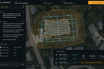
Skirrus is a chat-first drone mission planner that allows users to describe a job in natural language and receive an AI-generated flight plan. The product uses a hybrid approach where AI interprets intent and constraints, while deterministic code handles geospatial calculations, route geometry, validation, and export.
What changed
The author describes Skirrus as an exploration of how AI can make complex technical workflows more approachable without hiding uncertainty or taking ownership of safety-critical decisions. It is presented as a tool for drone pilots who understand what they want to do but lack GIS or mission-planning expertise.
Single most important open question
Is there evidence that Skirrus has been validated in real-world use cases beyond the hackathon prototype, and does it have any traction or adoption among drone operators?
What The Product Actually Is
The description states that Skirrus is a chat-first drone mission planner. Users describe a location, desired outcome, aircraft, and optional capture settings in natural language.
Key technical components include:
- A React + TypeScript frontend
- Node.js + Express backend
- Integration with OpenAI's GPT-5.6 model via typed planning tools
- Geographic services such as Google Places, Nominatim, OpenStreetMap Overpass, and Open-Topo-Data
- Deterministic code for route geometry, camera math, validation, and export
The system separates AI interpretation from deterministic execution:
- GPT interprets intent, extracts constraints, chooses mission strategy, and explains results.
- Deterministic code owns coordinates, route geometry, validation, and export.
It supports exporting missions in formats like DJI Fly KMZ, Skirrus JSON, or GeoJSON.
Inference The product is a prototype built for a hackathon; no evidence of production deployment or customer usage exists.
Positioning & Claim Evolution
The author positions Skirrus as:
- A tool that bridges the gap between human descriptions of drone jobs and detailed flight plans.
- An exploration into how AI can make complex workflows approachable without hiding uncertainty or taking responsibility for safety-critical decisions.
Claims made:
- AI makes a complex technical workflow approachable without hiding uncertainty or taking ownership of safety-critical calculations.
- The project explores how AI can interpret intent while deterministic code handles mathematical and flight-critical claims.
- It demonstrates a pattern for operational AI: let the model interpret intent and coordinate tools, but require sourced evidence, deterministic calculations, visible uncertainty, and human approval before action.
Inference These are self-stated claims about design philosophy and potential impact. No evidence of market validation or product-market fit is provided.
Target Customer & ICP
The description states that Skirrus targets:
- Drone pilots
- Photographers
- Inspectors
- Surveyors
- Small teams
These users understand the job they need to perform but may not have specialized GIS or mission-planning expertise.
Inference The target customer profile is inferred from the author's stated use case. No evidence of actual customers, personas, or segmentation data exists.
Business Model & Pricing Evidence
There is no mention of pricing, monetization strategy, or business model in the description.
Not evidenced
Technical & Delivery Signals
Key technical signals:
- Built with React, TypeScript, Vite, MapLibre GL JS, Node.js, Express
- Uses GPT-5.6 via OpenAI API with typed planning tools
- Integrates multiple geographic data sources (Google Places, Nominatim, OpenStreetMap Overpass, etc.)
- Implements deterministic code for geospatial calculations and export generation
- Includes a Plan Inspector showing AI decisions, evidence, and operator actions
- Supports DJI Fly KMZ export verified using native RC 2 mission data
The architecture separates AI interpretation from deterministic execution:
- GPT selects and revises mission intent.
- Deterministic code owns coordinates, route geometry, validation, and export.
Inference The technical stack and architecture suggest a well-thought-out hybrid approach. However, no evidence of scalability, performance metrics, or production deployment is provided.
Traction & Maturity Signals
The project was submitted to the OpenAI 2026 hackathon on Devpost.
No evidence of:
- Revenue
- Customers
- Adoption
- Usage data
- Product-market fit
- Market traction
Not evidenced
Competitive Context
There is no mention of competitors or competitive landscape in the description.
Not evidenced
Open Questions & Risks
Key risks and open questions:
- The product is described as a hackathon prototype with no evidence of real-world validation.
- No revenue, customer, or traction data is available.
- The author notes that DJI export support remained blocked until native mission files confirmed required aircraft values — suggesting incomplete functionality.
- The system relies heavily on external geographic services that can be slow, ambiguous, unavailable, or rate-limited.
- There is no indication of how the product will scale beyond a single developer's implementation.
Inference The lack of real-world testing and validation raises concerns about readiness for commercial deployment.
Questions the description leaves open
- What specific feedback have you received from drone operators or industry professionals outside of the hackathon?
- How do you plan to validate the accuracy of AI-generated flight plans in real-world conditions?
- Have you conducted any field tests using imported RC 2 missions and post-flight telemetry?
- What is your roadmap for integrating airspace awareness, terrain data, and obstacle detection?
- Are there any regulatory or safety compliance considerations that need to be addressed before commercial use?
Overall Assessment
The description indicates that Skirrus is a hackathon prototype built by a single developer with no team or funding. There is no evidence of revenue, customers, traction, or product-market fit.
Assessment Not ready for investment or partnership at this stage. The concept shows promise in addressing a real need for drone operators, but lacks validation and maturity indicators. Further development and field testing are required before considering commercial viability.
User Stories BotA demo video on every pull request
Get a demo video on every new feature
GitHub App that watches your pull requests and records a narrated, captioned demo.
Save time on demo prep and make informed decisions faster with a video walkthrough of every new feature.
Source
Submitted to the OpenAI 2026 hackathon on Devpost. Project home on Devpost. Back to the full gallery on Devpost.
This competitive analysis was produced by top-founders.com (opens in a new tab)
Generated by a language model from this project's public Devpost page — its tagline, the author's own write-up and any built-with tags listed there — as captured in August 2026. Short quotations are the author's words. It is an opinion on the idea as a business, not on the people behind it, and it reflects the description as published then. If the project has moved on, request a correction below. The analysis is not independent research and contains no verified traction, revenue or customer data.
An independent guide by KFG International LLC — not affiliated with, endorsed by, or connected to Devpost or OpenAI.