

Archive position — measured, not model output
5 likes on Devpost
54 of the 7,850 archived projects have more likes, and 35 share exactly 5 — so this project's #82 place in the like-ranked listing is a tie-break inside that group, not a ranking.
Projects (log scale)
Likes on Devpost. ▲ marks this project's group.
Show the figures
| Likes | Projects | Share of archive |
|---|---|---|
| 0 | 5,587 | 71.2% |
| 1 | 1,758 | 22.4% |
| 2 | 284 | 3.6% |
| 3–4 | 132 | 1.7% |
| 5–9 | 75 | 1.0% |
| 10+ | 14 | 0.2% |
 User Stories BotA demo video on every pull request
Get a demo video on every new feature
GitHub App that watches your pull requests and records a narrated, captioned demo.
Save time on demo prep and make informed decisions faster with a video walkthrough of every new feature.
Executive Summary
Company: SafeZone.os
Self-reported basis: The entire analysis is based on the project description provided by the caller — a self-reported write-up from the team that submitted it to the OpenAI 2026 hackathon. No independent verification or archived evidence exists for this project.
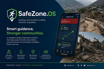
What the company appears to be: SafeZone.os is an intelligent disaster preparedness platform designed to guide users toward safe routes and shelters during natural disasters like earthquakes, landslides, and floods. It integrates geospatial data, real-time alerts, and risk analysis to provide life-saving information in critical moments.
What changed: The project was submitted as a hackathon entry (Devpost submission), indicating it is currently in prototype or early-stage development. There is no evidence of prior traction, revenue, or customer adoption.
Single most important open question: Is there sufficient evidence that SafeZone.os can scale beyond a prototype to deliver real-world impact in vulnerable communities?
What The Product Actually Is
The description states:
- SafeZone.os is an intelligent disaster preparedness platform.
- It helps people identify the safest evacuation routes and shelters during natural hazards such as earthquakes, landslides, and floods.
- It combines geospatial information, real-time alerts, and risk analysis to provide clear guidance.
Inference: The product appears to be a location-based service with risk-aware routing and shelter recommendations. It is not described as a commercial SaaS offering or a consumer app but rather as a tool for emergency preparedness.
Evidence strength: Evidenced
Positioning & Claim Evolution
The description states:
- The platform aims to reduce fatal accidents through prevention, real-time technology, and rapid emergency response.
- It is built with empathy and accessibility in mind, targeting underserved populations.
- The team emphasizes that the solution is community-driven and not based on assumptions.
Inference: Positioning focuses on social impact and accessibility rather than commercial scalability. The platform is positioned as a public good or emergency tool for vulnerable communities.
Evidence strength: Evidenced
Target Customer & ICP
The description states:
- The target audience includes people in vulnerable communities, especially those affected by earthquakes, landslides, and floods.
- It is designed to be accessible even for users with limited resources or technical knowledge.
- Specific mention of Chosica, Peru, as a high-risk area.
Inference: The ICP appears to be individuals living in disaster-prone regions, particularly low-income or underserved populations who may lack access to traditional emergency services.
Evidence strength: Evidenced
Business Model & Pricing Evidence
The description does not state:
- Whether the platform is monetized.
- If there are any pricing models or revenue streams.
- Whether it is intended for public use, government deployment, or NGO partnerships.
Inference: No evidence of a business model or pricing structure. The project seems to be focused on social impact rather than commercial viability.
Evidence strength: Not evidenced
Technical & Delivery Signals
The description states:
- Built with: claude, google-maps, ia, lovable, python.
- Integrates hazard maps, geospatial data, and emergency preparedness guidelines.
- Designed to work during emergencies when connectivity or power may be compromised.
- Aims to support offline capabilities.
Inference: The platform uses modern mapping and AI tools. It is intended for deployment in low-resource environments with potential offline functionality.
Evidence strength: Evidenced
Traction & Maturity Signals
The description states:
- Submitted as a hackathon project (Devpost).
- Team size: 3.
- No mention of users, customers, or adoption.
- No revenue, ARR, or funding rounds are mentioned.
Inference: The platform is in early development and has not yet demonstrated traction or market readiness.
Evidence strength: Not evidenced
Competitive Context
The description does not state:
- Whether similar platforms exist.
- Who the competitors are.
- How SafeZone.os differentiates from existing tools in disaster preparedness or emergency response.
Inference: No competitive landscape is described. The project may be unique, but this cannot be confirmed without external data.
Evidence strength: Not evidenced
Open Questions & Risks
The description states:
- Challenges include designing for emergencies with limited connectivity and power.
- The solution must remain accessible to non-technical users.
- There is no mention of partnerships, pilot deployments, or validation in real-world settings.
Inference: Risks include:
- Lack of real-world testing.
- Uncertainty about scalability or usability in actual disasters.
- No evidence of stakeholder engagement or institutional support.
Evidence strength: Inferred from description
Questions the description leaves open
- What specific partnerships have been established with local governments, NGOs, or emergency response agencies?
- Has the platform undergone any real-world testing or pilot deployment in high-risk areas like Chosica?
- How is the geospatial and hazard data updated, and what is the frequency of updates?
- Is there a plan for monetization or long-term sustainability beyond the hackathon phase?
- What are the technical limitations of offline functionality, and how is user data handled in emergency scenarios?
Overall Assessment
The description states:
- The project is currently a prototype.
- It aims to become scalable and support vulnerable communities across Peru and beyond.
- There is no evidence of revenue, customers, or traction.
Inference: At this stage, the project is not ready for investment or partnership. It is in early development with a strong social mission but lacks commercial or operational signals.
Evidence strength: Inferred from description
User Stories BotA demo video on every pull request
Get a demo video on every new feature
GitHub App that watches your pull requests and records a narrated, captioned demo.
Save time on demo prep and make informed decisions faster with a video walkthrough of every new feature.
Source
Submitted to the OpenAI 2026 hackathon on Devpost. Project home on Devpost. Back to the full gallery on Devpost.
This competitive analysis was produced by top-founders.com (opens in a new tab)
Generated by a language model from this project's public Devpost page — its tagline, the author's own write-up and any built-with tags listed there — as captured in August 2026. Short quotations are the author's words. It is an opinion on the idea as a business, not on the people behind it, and it reflects the description as published then. If the project has moved on, request a correction below. The analysis is not independent research and contains no verified traction, revenue or customer data.
An independent guide by KFG International LLC — not affiliated with, endorsed by, or connected to Devpost or OpenAI.