

Archive position — measured, not model output
0 likes on Devpost
2,263 of the 7,850 archived projects have more likes, and 5,587 share exactly 0 — so this project's #5,819 place in the like-ranked listing is a tie-break inside that group, not a ranking.
Projects (log scale)
Likes on Devpost. ▲ marks this project's group.
Show the figures
| Likes | Projects | Share of archive |
|---|---|---|
| 0 | 5,587 | 71.2% |
| 1 | 1,758 | 22.4% |
| 2 | 284 | 3.6% |
| 3–4 | 132 | 1.7% |
| 5–9 | 75 | 1.0% |
| 10+ | 14 | 0.2% |
 User Stories BotA demo video on every pull request
Get a demo video on every new feature
GitHub App that watches your pull requests and records a narrated, captioned demo.
Save time on demo prep and make informed decisions faster with a video walkthrough of every new feature.
Executive Summary
What the company appears to be
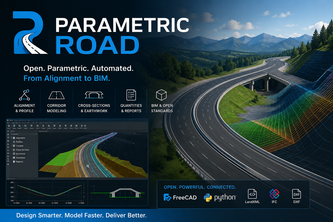
Parametric Road is a self-reported open-source, FreeCAD-based platform for road design that automates alignment, profiles, cross-sections, corridor modeling, and earthwork quantities using Python. It is built as a custom FreeCAD Workbench.
What changed
The project was submitted to the OpenAI 2026 hackathon by one developer (호연 경), who describes it as an experimental tool aimed at replacing proprietary road design software with an open, parametric alternative.
Single most important open question
Is there evidence of any real-world usage or adoption beyond this hackathon submission?
What The Product Actually Is
The description states that Parametric Road is a parametric road-design platform built on FreeCAD, using Python and the FreeCAD API. It automates:
- Horizontal and vertical alignments
- Profiles (existing and finished-grade)
- 3D centerlines
- Cross-sections
- Corridor modeling
- Cut and fill analysis
- BIM-ready outputs
It uses a workflow that begins with terrain data and proceeds through alignment, profiles, 3D centerline, assembly, cross-sections, corridor, and quantities.
The system generates 3D centerlines using parametric equations and connects road assemblies along the centerline. It supports CSV and LandXML for data exchange.
Inference The tool is described as a custom FreeCAD Workbench, not a standalone application or SaaS product.
Positioning & Claim Evolution
The description states that Parametric Road was inspired by the high cost, limited flexibility, and proprietary workflows of conventional road-design software. It aims to provide an open and programmable alternative using FreeCAD and Python.
It positions itself as a tool for automating practical road modeling, with a focus on parametric design, reproducibility, and accessibility.
The author claims that it can generate road geometry from engineering parameters rather than relying on manual modeling. It also states that the project demonstrates FreeCAD’s potential as a civil-engineering platform.
Inference The positioning is experimental and early-stage, aimed at developers or engineers seeking open-source alternatives to proprietary tools.
Target Customer & ICP
The description does not identify specific customer segments or personas. However, it implies an audience of:
- Civil engineers
- Road design professionals
- Developers working with FreeCAD or CAD platforms
It is described as a FreeCAD-based tool, suggesting that its primary users would be those already using or familiar with FreeCAD.
Inference The ICP appears to be engineers and developers in civil infrastructure, but no explicit targeting or segmentation is stated.
Business Model & Pricing Evidence
The description does not mention any pricing, monetization, or business model. It is described as an open-source platform, with no indication of commercial use or revenue streams.
Inference No evidence of a business model or pricing structure exists in the provided description.
Technical & Delivery Signals
- Built as a custom FreeCAD Workbench
- Uses Python and the FreeCAD API
- Supports workflows involving:
- Terrain data
- Alignment
- Profiles
- 3D centerline generation
- Cross-sections
- Corridor modeling
- Cut and fill analysis
- Data exchange via CSV and LandXML
- Uses parametric equations to define 3D centerlines:
$$
\mathbf{C}(s)=
\begin{bmatrix}
x(s) \\
y(s) \\
z(s)
\end{bmatrix}
$$
Inference The tool is technical and experimental, built for developers or engineers familiar with FreeCAD. It is not described as a commercial product or SaaS.
Traction & Maturity Signals
The project was submitted to the OpenAI 2026 hackathon, indicating it is early-stage and likely experimental.
It has no evidence of:
- Revenue
- Customers
- Adoption
- Product-market fit
- Commercial traction
Inference The tool is in a pre-product-market-fit stage, with no demonstrated usage beyond the hackathon submission.
Competitive Context
The description does not mention specific competitors. However, it implies a context of conventional proprietary road design software, which typically includes tools like:
- AutoCAD Civil 3D
- MicroStation
- InRoads
It positions itself as an open-source alternative to such tools.
Inference The competitive space is well-established, with no indication that Parametric Road has differentiated or gained traction in the market.
Open Questions & Risks
- No evidence of real-world usage or adoption
- One-person team suggests limited development capacity
- Hackathon submission implies experimental and non-commercial nature
- Open-source, but no indication of community, contributors, or sustainability
- No pricing, monetization, or business model described
- Technical complexity (e.g., parametric CAD, 3D geometry) may limit accessibility to non-experts
Questions the description leaves open
- What is the intended user base for Parametric Road beyond the hackathon?
- Has there been any real-world testing or feedback from civil engineers or developers using it?
- Are there plans to build a community or ecosystem around this tool?
- How does it compare to existing open-source CAD tools in terms of usability and adoption?
- What are the long-term goals for monetization, if any?
- Is there any plan to support commercial software integrations or APIs?
Overall Assessment
Not evidenced.
The description provides no evidence of traction, revenue, customers, or a clear business model. It is an early-stage hackathon project with no indication of commercial viability or market demand.
Confidence: Low.
This is a self-reported, unverified, experimental tool, not a product or company with demonstrated commercial potential. Any investment or partnership decision would require further evidence of usage, adoption, and development progress beyond this submission.
User Stories BotA demo video on every pull request
Get a demo video on every new feature
GitHub App that watches your pull requests and records a narrated, captioned demo.
Save time on demo prep and make informed decisions faster with a video walkthrough of every new feature.
Source
Submitted to the OpenAI 2026 hackathon on Devpost. Project home on Devpost. Back to the full gallery on Devpost.
This competitive analysis was produced by top-founders.com (opens in a new tab)
Generated by a language model from this project's public Devpost page — its tagline, the author's own write-up and any built-with tags listed there — as captured in August 2026. Short quotations are the author's words. It is an opinion on the idea as a business, not on the people behind it, and it reflects the description as published then. If the project has moved on, request a correction below. The analysis is not independent research and contains no verified traction, revenue or customer data.
An independent guide by KFG International LLC — not affiliated with, endorsed by, or connected to Devpost or OpenAI.