

Archive position — measured, not model output
1 like on Devpost
505 of the 7,850 archived projects have more likes, and 1,758 share exactly 1 — so this project's #1,352 place in the like-ranked listing is a tie-break inside that group, not a ranking.
Projects (log scale)
Likes on Devpost. ▲ marks this project's group.
Show the figures
| Likes | Projects | Share of archive |
|---|---|---|
| 0 | 5,587 | 71.2% |
| 1 | 1,758 | 22.4% |
| 2 | 284 | 3.6% |
| 3–4 | 132 | 1.7% |
| 5–9 | 75 | 1.0% |
| 10+ | 14 | 0.2% |
 User Stories BotA demo video on every pull request
Get a demo video on every new feature
GitHub App that watches your pull requests and records a narrated, captioned demo.
Save time on demo prep and make informed decisions faster with a video walkthrough of every new feature.
Executive Summary
What the company appears to be
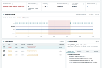
LiDAR Forensics is a self-reported diagnostic application for analyzing multistream sensor data from mobile LiDAR systems. The author states it distinguishes between sensor-specific failures (e.g., LiDAR-only stalls) and recording-wide gaps, presents structured findings, and supports export of results in multiple formats.
What changed
The project evolved from a one-off forensic investigation into a reproducible software tool that can be applied to similar sensor failure scenarios. It was submitted as part of the OpenAI 2026 hackathon.
Single most important open question
Is there any evidence of real-world adoption, usage or traction beyond the author’s own investigation and demonstration datasets?
This analysis is based entirely on the self-reported project description provided by the caller. No third-party verification, archived data, revenue figures, customer names, or traction metrics are available.
What The Product Actually Is
The description states that LiDAR Forensics analyzes synchronized event metadata from multiple sensor streams including LiDAR, IMU, motor, encoder, GPS/GNSS, and recorder. It detects and classifies various failure types such as:
- LiDAR-only publication stalls;
- Recording-wide gaps affecting all streams;
- Stale timestamps after stream resumption;
- Post-stall catch-up bursts;
- Repeated interruptions;
- Premature stream termination.
It presents an interactive multistream timeline, incident classification, a structured Finding register, and exportable results in CSV, JSON, HTML, and Markdown formats.
The application does not perform full point-cloud reconstruction but focuses on diagnosis, evidence packaging, and failure classification. The author notes that point-cloud recovery depends on which real measurements, timestamps, calibration data, and trajectory information survived in a specific recording.
Claim: The product is a diagnostic tool for multistream sensor failures.
Evidence: Author's own write-up.
Positioning & Claim Evolution
The project was initially inspired by a personal forensic investigation into a LiDAR-only stall during a real mobile survey. The author did not accept that the processing pipeline had lost all data and instead investigated raw streams to determine what actually stopped, what continued, and whether usable measurements remained.
This led to the creation of a reusable diagnostic application aimed at separating confirmed evidence from engineering hypotheses and determining if damaged recordings may still contain recoverable data.
The positioning has evolved from a one-time field investigation into a general-purpose tool for diagnosing multistream sensor failures in mobile mapping systems. The author emphasizes that the tool is conservative, does not synthesize missing data, and focuses on structured reporting rather than reconstruction.
Claim: LiDAR Forensics distinguishes sensor-specific stalls from recording-wide gaps, exposes timing evidence, and generates conservative findings without proprietary data.
Evidence: Tagline + author's own write-up.
Target Customer & ICP
Not evidenced. The description does not identify specific customer segments or personas. It does not name potential users, industries, or use cases beyond the context of mobile LiDAR surveys and sensor diagnostics.
Claim: Not stated.
Evidence: None provided.
Business Model & Pricing Evidence
Not evidenced. There is no mention of pricing models, monetization strategies, or business structure in the description. The tool appears to be open-source and publicly available via GitHub.
Claim: Not stated.
Evidence: None provided.
Technical & Delivery Signals
The backend uses Python, FastAPI, and Pydantic. It applies deterministic rules to normalized multistream event data, evaluating stream continuity, message timing, inter-message gaps, timestamp behavior, stream resumption, and relationships between sensors.
Frontend is built with static HTML, CSS, JavaScript, and native SVG for rendering timelines directly in the browser.
Supports input adapters for CSV, JSON, ROS1 BAG, and MCAP formats. Includes three deterministic demonstration datasets (normal recording, LiDAR stall, recording-wide gap).
Automated tests cover detection rules, input adapters, API behavior, exports, interface contracts, and desktop/mobile presentation.
Codex and GPT-5.6 Sol were used to assist in developing the application, but the human engineer provided core engineering interpretation, validation criteria, and failure taxonomy.
Claim: The tool uses deterministic rule-based analysis with normalized data inputs.
Evidence: Author's own write-up.
Traction & Maturity Signals
Not evidenced. There is no mention of revenue, customers, user base, or product adoption beyond the author’s own investigation and demonstration datasets. No production deployment, usage statistics, or feedback from external users are reported.
Claim: Not stated.
Evidence: None provided.
Competitive Context
Not evidenced. The description does not reference existing tools or platforms in the LiDAR diagnostics space. No competitive landscape or differentiation strategy is discussed.
Claim: Not stated.
Evidence: None provided.
Open Questions & Risks
- Lack of traction or adoption — No evidence of real-world usage beyond the author’s own investigation and demo datasets.
- Limited scope — The tool does not perform point-cloud reconstruction, which may limit its utility for some users.
- No commercialization path — No indication of monetization, pricing, or business model.
- Self-reported only — All claims are unverified; no independent validation or third-party data exists.
- Single-person team — The project is developed by one individual, raising questions about scalability and long-term maintenance.
Inference: Without evidence of traction, commercial viability, or user feedback, the risk of misalignment between stated goals and actual utility is high.
Questions the description leaves open
- What real-world deployments or use cases have you seen for this tool?
- Have you received any feedback from users outside your own investigation?
- Are there plans to expand beyond mobile mapping systems or sensor types?
- How do you plan to monetize or scale the product?
- What are the technical limitations of the current implementation that prevent broader adoption?
These questions aim to uncover whether the tool has moved beyond a proof-of-concept into practical application.
Overall Assessment
Not evidenced. There is no indication of funding, valuation, or investment interest in the project. No financials, milestones, or strategic partnerships are mentioned.
Claim: Not stated.
Evidence: None provided.
User Stories BotA demo video on every pull request
Get a demo video on every new feature
GitHub App that watches your pull requests and records a narrated, captioned demo.
Save time on demo prep and make informed decisions faster with a video walkthrough of every new feature.
Source
Submitted to the OpenAI 2026 hackathon on Devpost. Project home on Devpost. Back to the full gallery on Devpost.
This competitive analysis was produced by top-founders.com (opens in a new tab)
Generated by a language model from this project's public Devpost page — its tagline, the author's own write-up and any built-with tags listed there — as captured in August 2026. Short quotations are the author's words. It is an opinion on the idea as a business, not on the people behind it, and it reflects the description as published then. If the project has moved on, request a correction below. The analysis is not independent research and contains no verified traction, revenue or customer data.
An independent guide by KFG International LLC — not affiliated with, endorsed by, or connected to Devpost or OpenAI.