

Archive position — measured, not model output
0 likes on Devpost
2,263 of the 7,850 archived projects have more likes, and 5,587 share exactly 0 — so this project's #4,163 place in the like-ranked listing is a tie-break inside that group, not a ranking.
Projects (log scale)
Likes on Devpost. ▲ marks this project's group.
Show the figures
| Likes | Projects | Share of archive |
|---|---|---|
| 0 | 5,587 | 71.2% |
| 1 | 1,758 | 22.4% |
| 2 | 284 | 3.6% |
| 3–4 | 132 | 1.7% |
| 5–9 | 75 | 1.0% |
| 10+ | 14 | 0.2% |
 User Stories BotA demo video on every pull request
Get a demo video on every new feature
GitHub App that watches your pull requests and records a narrated, captioned demo.
Save time on demo prep and make informed decisions faster with a video walkthrough of every new feature.
Executive Summary
What the company appears to be
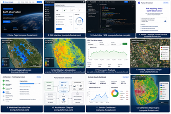
FluviSat AI is a self-reported geospatial AI agent that translates natural language into executable satellite analysis workflows. The platform uses OpenAI's GPT-5.6 and Codex to interpret user requests, generate code, and execute analyses on large satellite datasets using cloud infrastructure.
What changed
This project was submitted as part of the OpenAI 2026 hackathon. It represents a self-described proof-of-concept or prototype for an AI-powered geospatial analysis tool that aims to democratize access to satellite data by removing programming barriers.
Single most important open question
Is there evidence of any actual user adoption, revenue generation, or customer traction beyond the author's own description?
The description states that FluviSat AI is a natural language interface for satellite data processing. It claims integration with GPT-5.6 and Codex, and mentions building an operational cloud-native platform. However, no evidence exists regarding actual users, customers, revenue, or product-market fit beyond the author's own account.
What The Product Actually Is
The description states that FluviSat AI is "an intelligent geospatial agent that converts natural language into executable Earth observation workflows." It claims to:
- Use GPT-5.6 for understanding user intent
- Generate geospatial analysis code using Codex
- Execute workflows on cloud computing infrastructure
- Process large satellite datasets
- Produce maps, charts, statistics, and downloadable outputs
- Explain processing steps in plain English
The system is described as connecting AI reasoning directly with cloud-based geospatial computing to enable natural language to become executable scientific workflows.
Positioning & Claim Evolution
The description states that FluviSat AI aims to "remove this barrier" by allowing anyone to describe their analysis in natural language instead of writing code. It positions itself as a tool for researchers, governments, businesses, and non-programmers to access satellite analytics.
The author claims the platform makes "advanced satellite analytics accessible" and that it can perform tasks like detecting flooded areas, calculating vegetation health, measuring soil moisture changes, identifying newly constructed buildings, and comparing satellite imagery between dates.
Future work includes multi-agent collaboration, automatic report generation, real-time disaster monitoring, agricultural decision support, autonomous environmental monitoring, integration with additional Earth observation missions, interactive conversational mapping, and support for custom plugins. These claims suggest an evolution toward more sophisticated AI-powered geospatial analysis capabilities.
Target Customer & ICP
The description states that FluviSat AI is intended for "researchers, governments, businesses, and non-programmers." It aims to make satellite analytics accessible to these groups who may not have specialized programming knowledge or geospatial software expertise.
The author also mentions targeting scientists, students, and decision makers as users of the interface. However, no evidence exists regarding specific customer segments, personas, or whether any actual customers exist beyond the author's own description.
Business Model & Pricing Evidence
Not evidenced. The description does not contain any information about pricing models, monetization strategies, or business model assumptions. There is no mention of subscription tiers, usage-based pricing, enterprise licensing, or any commercial arrangements.
Technical & Delivery Signals
The description states that FluviSat AI was built using several technologies including:
- GPT-5.6 for understanding user intent
- Codex for automatic workflow and code generation
- FluviSat Compute Engine for scalable cloud execution
- Azure Kubernetes Service for distributed processing
- Dask for parallel computation
- Python geospatial libraries (Rasterio, GDAL, Xarray, NumPy, GeoPandas)
- Azure Blob Storage for large satellite datasets
- Interactive web interface built with React and JavaScript
The system is described as a "cloud-native geospatial computing platform" that connects AI reasoning directly with cloud-based geospatial computing. It claims to be operational and capable of processing large remote sensing datasets.
Traction & Maturity Signals
Not evidenced. The description does not contain any information about user adoption, customer acquisition, revenue generation, or product-market fit beyond the author's own account. There is no evidence of actual users, customers, or traction data.
The project was submitted to a hackathon and described as "operational" but this self-reporting does not constitute verified traction or maturity signals.
Competitive Context
Not evidenced. The description does not contain any information about existing competitors, market positioning, competitive advantages, or competitive landscape analysis. No mention of similar products or services in the geospatial AI space is provided.
Open Questions & Risks
- Unverified claims: All evidence is self-reported and unverified
- No traction evidence: No customers, revenue, or adoption data provided
- Single-person team: The project has only one team member (Chandana Gangoda)
- Hackathon context: Submitted to a hackathon suggests prototype rather than mature product
- Technology stack risks: Heavy reliance on specific AI models and cloud infrastructure that may not be scalable or reliable
- Ambiguity in execution: Challenges mentioned include translating ambiguous natural language into precise processing steps, which suggests technical complexity and potential reliability issues
Questions the description leaves open
- What specific satellite missions or data sources does the platform currently support?
- How many actual users or customers exist beyond the author's own description?
- What is the current revenue model or monetization strategy?
- What are the technical limitations of the current system that prevent it from being production-ready?
- How does the platform handle edge cases where natural language requests are ambiguous or unclear?
- What specific geospatial analysis tasks can currently be performed, and what are the accuracy and reliability metrics?
- How is data privacy and security handled for sensitive satellite imagery?
- What are the actual computational requirements and costs of running these workflows?
- How does the platform ensure reproducibility and transparency in its generated analyses?
- What specific partnerships or integrations exist with satellite data providers or government agencies?
Overall Assessment
Not evidenced. The description provides no information about financial performance, customer base, revenue, or market traction that would inform an investment or partnership decision. The project appears to be a hackathon submission with no verified commercial activity beyond the author's own claims.
The single-person team, hackathon context, and lack of any verifiable traction or commercial evidence make this a high-risk opportunity with limited due-diligence evidence available for evaluation. Any investment or partnership decision would require substantial additional verification of the claims made in the description.
User Stories BotA demo video on every pull request
Get a demo video on every new feature
GitHub App that watches your pull requests and records a narrated, captioned demo.
Save time on demo prep and make informed decisions faster with a video walkthrough of every new feature.
Source
Submitted to the OpenAI 2026 hackathon on Devpost. Project home on Devpost. Back to the full gallery on Devpost.
This competitive analysis was produced by top-founders.com (opens in a new tab)
Generated by a language model from this project's public Devpost page — its tagline, the author's own write-up and any built-with tags listed there — as captured in August 2026. Short quotations are the author's words. It is an opinion on the idea as a business, not on the people behind it, and it reflects the description as published then. If the project has moved on, request a correction below. The analysis is not independent research and contains no verified traction, revenue or customer data.
An independent guide by KFG International LLC — not affiliated with, endorsed by, or connected to Devpost or OpenAI.