

Archive position — measured, not model output
1 like on Devpost
505 of the 7,850 archived projects have more likes, and 1,758 share exactly 1 — so this project's #2,060 place in the like-ranked listing is a tie-break inside that group, not a ranking.
Projects (log scale)
Likes on Devpost. ▲ marks this project's group.
Show the figures
| Likes | Projects | Share of archive |
|---|---|---|
| 0 | 5,587 | 71.2% |
| 1 | 1,758 | 22.4% |
| 2 | 284 | 3.6% |
| 3–4 | 132 | 1.7% |
| 5–9 | 75 | 1.0% |
| 10+ | 14 | 0.2% |
 User Stories BotA demo video on every pull request
Get a demo video on every new feature
GitHub App that watches your pull requests and records a narrated, captioned demo.
Save time on demo prep and make informed decisions faster with a video walkthrough of every new feature.
Executive Summary
What the company appears to be
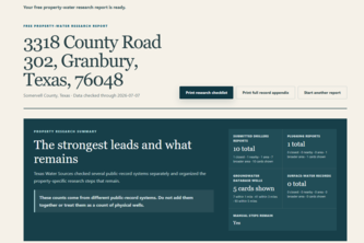
Texas Water Sources - Free Property Water Report is a self-reported public tool that allows users to enter a Texas property address and receive a free, source-linked snapshot of water-related records. The system claims to aggregate fragmented government data into a structured research report, separating findings by source family and preserving provenance, dates, uncertainty, and limitations.
What changed
The author states they transformed an internal private platform into a deployed public product during Build Week using GPT-5.6 and Codex. The tool was designed to help Texans research property-water questions without making incomplete public records into false answers.
Single most important open question — the commercial due-diligence read
Is there any evidence of user adoption, revenue generation or customer traction beyond the author’s own testing? The description contains no data on usage volume, customer acquisition, monetization, or market validation.
What The Product Actually Is
The description states that Texas Water Sources is a system that:
- Accepts a Texas property address.
- Reviews possible address candidates and requires user confirmation before generating a report.
- Produces a free, source-linked water-record snapshot organized by source family.
- Includes groundwater-conservation-district context, submitted well-report candidates, plugging reports, observation data, surface-water rights, official links, seller and professional research questions, and a printable handoff.
- Does not claim ownership, predict availability, or represent historical measurements as current yield or quality.
- Operates without requiring an account.
The system is described as a controlled translation layer between complex government records and an understandable property-research workflow. It uses a private Python backend for data normalization and a static Next.js frontend for presentation.
Inference The product appears to be a research tool, not a database search or chatbot. It is built with cloud infrastructure, Docker, FastAPI, React, and various GIS tools like ESRI and PyProj.
Positioning & Claim Evolution
The author states that the project was inspired by difficulties in navigating fragmented Texas water data systems while buying land and helping others research property questions.
Key claims:
- The tool helps Texans understand what public records were located, what those records may help them investigate, and what limitations apply.
- It does not mix unrelated database counts into misleading totals.
- It avoids claiming that nearby records belong to the property or determining ownership.
- It aims to save time and guide users on how to proceed with further research.
The positioning appears to be a utility for property researchers seeking accurate, source-backed information without account requirements or commercial intent. There is no evidence of branding, marketing claims, or competitive positioning beyond its stated purpose.
Inference The evolution from an internal tool to a public product reflects a shift toward democratizing access to government data, but the author does not describe any strategic pivot or market expansion.
Target Customer & ICP
The description states:
- The primary users are Texans researching property-water questions.
- It is intended for individuals buying land or conducting property research.
- Users must confirm an address candidate before a report is generated.
- No account is required, suggesting low friction entry for casual users.
There is no evidence of segmentation beyond "property researchers" or any indication of specific buyer personas, use cases, or customer types beyond the self-reported user base.
Inference The ICP likely includes private individuals, real estate agents, or landowners in Texas who need to understand water-related records associated with a property. No evidence exists for institutional or B2B adoption.
Business Model & Pricing Evidence
The description states:
- The service is free.
- No account is required.
- There are no pricing tiers or monetization mechanisms described.
- The author notes that the tool was built to help Texans save time and know what to research, not to generate revenue.
There is no evidence of any commercial model, subscriptions, paid features, or monetization strategy beyond the free offering.
Inference The business model appears to be non-commercial, with no indication of future plans for monetization or scaling into a paid service.
Technical & Delivery Signals
The system is built using:
- Private backend in Python managing normalized government records.
- A bounded lookup service converting managed records into privacy-filtered public responses.
- Static Next.js frontend handling address entry, candidate confirmation, and report presentation.
- Integration between two Git repositories and environments.
- Closed request/response schemas to maintain data safety.
- Use of tools like Docker, FastAPI, Playwright, PyArrow, Shapely, GeoPandas, and ESRI.
The author mentions:
- Address-candidate confirmation process.
- Server-side handling of exact coordinates.
- Separation of findings by source family.
- Deterministic testing without live geocoder.
- Cross-repository contract validation.
- Mobile, accessibility, metadata, privacy, and print testing.
Inference The technical stack suggests a well-thought-out approach to data privacy, user experience, and system integrity. However, no evidence exists regarding scalability, performance metrics, or deployment history beyond the single developer’s work.
Traction & Maturity Signals
The description states:
- The tool was deployed during Build Week.
- It is live and usable without an account.
- Users tested it on real research tasks for homes being purchased in Texas.
- Feedback was positive regarding time saved and accuracy.
- The author had people test it on actual property purchases.
However, there is no evidence of:
- User metrics or volume.
- Customer retention or repeat usage.
- Revenue or monetization.
- Market traction beyond the author’s own testing.
- Any form of customer acquisition or marketing activity.
Inference The product shows early maturity in functionality and usability but lacks any measurable traction or user engagement data. It remains a prototype or proof-of-concept with limited external validation.
Competitive Context
The description does not mention competitors, nor does it describe how the tool compares to existing solutions for accessing Texas water records.
There is no evidence of:
- Competitor analysis.
- Market positioning relative to other tools.
- Existing platforms offering similar services.
- Industry benchmarks or market share.
Inference The competitive landscape is unknown. The author does not reference any comparable products or services in the Texas property-water data space.
Open Questions & Risks
Key risks and open questions based on the description:
- No revenue or monetization strategy: The tool is free, with no indication of future commercial plans.
- Single developer team: Only one member listed (aitradesniper-blip Wingate), which raises concerns about scalability and long-term maintenance.
- Lack of user data or traction: No evidence of usage volume, customer feedback, or adoption beyond author testing.
- Unverified claims: The tool is described as accurate and helpful, but no independent validation or third-party testing is provided.
- Dependency on AI tools: Heavy reliance on GPT-5.6 and Codex for development raises questions about reproducibility and sustainability if those tools change.
- No institutional support or partnerships: No mention of government collaboration, data licensing, or stakeholder engagement.
Inference The project is a personal initiative with no clear path to commercial viability or market traction. It lacks the signals typically associated with scalable or investable ventures.
Questions the description leaves open
- What specific government datasets are being used, and how are they accessed?
- How does the system handle discrepancies or conflicts between different data sources?
- Has there been any formal feedback from users beyond your own testing?
- Are there plans to expand beyond Texas or add more data types (e.g., soil, air, etc.)?
- What is the long-term vision for sustainability and scalability of the platform?
- How are you ensuring data accuracy and preventing misinterpretation by users?
- Do you have any plans for monetization or commercial partnerships in the future?
- What are the technical limitations or bottlenecks currently in place?
Overall Assessment
Not evidenced.
The description provides no evidence of:
- Revenue, ARR, or financial performance.
- Customer base or user traction.
- Market validation or competitive positioning.
- Any form of commercialization or monetization.
- Institutional support or data licensing agreements.
This is a self-reported, unverified tool built by one person during a hackathon. It shows early functionality and usability but lacks any indicators of commercial viability, scalability, or market demand.
Confidence level Low — the entire analysis is based on a single self-reported description with no external corroboration or data points.
User Stories BotA demo video on every pull request
Get a demo video on every new feature
GitHub App that watches your pull requests and records a narrated, captioned demo.
Save time on demo prep and make informed decisions faster with a video walkthrough of every new feature.
Source
Submitted to the OpenAI 2026 hackathon on Devpost. Project home on Devpost. Back to the full gallery on Devpost.
This competitive analysis was produced by top-founders.com (opens in a new tab)
Generated by a language model from this project's public Devpost page — its tagline, the author's own write-up and any built-with tags listed there — as captured in August 2026. Short quotations are the author's words. It is an opinion on the idea as a business, not on the people behind it, and it reflects the description as published then. If the project has moved on, request a correction below. The analysis is not independent research and contains no verified traction, revenue or customer data.
An independent guide by KFG International LLC — not affiliated with, endorsed by, or connected to Devpost or OpenAI.