

Archive position — measured, not model output
1 like on Devpost
505 of the 7,850 archived projects have more likes, and 1,758 share exactly 1 — so this project's #1,607 place in the like-ranked listing is a tie-break inside that group, not a ranking.
Projects (log scale)
Likes on Devpost. ▲ marks this project's group.
Show the figures
| Likes | Projects | Share of archive |
|---|---|---|
| 0 | 5,587 | 71.2% |
| 1 | 1,758 | 22.4% |
| 2 | 284 | 3.6% |
| 3–4 | 132 | 1.7% |
| 5–9 | 75 | 1.0% |
| 10+ | 14 | 0.2% |
 User Stories BotA demo video on every pull request
Get a demo video on every new feature
GitHub App that watches your pull requests and records a narrated, captioned demo.
Save time on demo prep and make informed decisions faster with a video walkthrough of every new feature.
Executive Summary
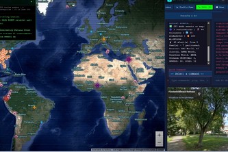
OrionEye is a self-reported web-based real-time geospatial analytics terminal built as a personal project by one developer (Lowegate Studio La Manna). The platform integrates live data from multiple sources—satellite orbits, air traffic, network telemetry, conflict tracking, and environmental feeds—into a single visual interface using technologies like WebGL, Canvas API, Leaflet.js, and various geospatial APIs. It is described as a "tactical terminal UI" with modular CLI support and visual shaders for different data types (e.g., Night Vision, Thermal). The author states that OrionEye was built to reduce operational friction in global intelligence workflows by fusing fragmented data into an intuitive dashboard.
The project is presented as a prototype or proof-of-concept, not yet commercialized. No evidence of revenue, customers, partnerships, or traction exists beyond the self-reported description.
Key open question: Is this a viable foundation for a product that could be scaled into a B2B SaaS offering, or does it remain a personal technical demonstration?
What The Product Actually Is
The description states that OrionEye is a web-based real-time geospatial terminal and intelligence hub, built as a personal project. It is described as:
- A visual dashboard integrating live data from multiple sources.
- A tactical terminal UI, designed with a modular Command-Line Interface (CLI) system.
- Equipped with custom visual pipeline shaders such as Night Vision/NVG, Thermal/FLIR, and Cyber HUD.
- Built using technologies including:
- Canvas API
- WebGL
- Leaflet.js
- Mapbox
- REST APIs (e.g., OpenSky Network, GDELT, NASA Earth API)
- JavaScript, Node.js, HTML5, CSS3
Inference: The platform is described as a real-time data fusion and visualization tool, not a commercial product or service.
Positioning & Claim Evolution
The author positions OrionEye as:
- A unified, high-performance visual dashboard for global real-time intelligence.
- Inspired by military command terminals and modern OSINT workflows.
- Designed to fuse digital infrastructure, spatial analytics, and live orbital dynamics into a single interface.
Claim: The platform aims to reduce operational friction in global data analysis by consolidating fragmented sources.
Inference: The positioning is technical and niche, targeting analysts, researchers, or developers working with geospatial and real-time data. It is not described as a general-purpose tool or consumer-facing product.
Target Customer & ICP
The description states that OrionEye is inspired by military command terminals and OSINT workflows, suggesting it targets:
- Analysts
- Researchers
- Developers working with geospatial or real-time data
- Possibly government or defense-related users
However, there is no evidence of a defined Ideal Customer Profile (ICP) beyond this general category.
Inference: The target customer is likely technical professionals in fields such as intelligence, cybersecurity, aerospace, or environmental monitoring. No explicit segmentation or buyer personas are provided.
Business Model & Pricing Evidence
The description does not provide any information about:
- A business model
- Pricing strategy
- Revenue streams
- Monetization plans
Inference: OrionEye is described as a personal project, not a commercial offering. There is no evidence of a monetized product or service.
Technical & Delivery Signals
The author reports building OrionEye with:
- A two-layer architecture: UI/FX engine and multi-source data ingestion pipeline.
- Integration of:
- CelesTrak API for satellite orbit tracking
- OpenSky Network API for aircraft tracking
- GDELT API for conflict monitoring
- NASA Earth Observatory feeds
- ESA launch event streams
- RIPE Atlas for network telemetry
Challenges mentioned include:
- High-frequency data fusion
- Coordinate and projection alignment
- API rate limiting and fallbacks
Inference: The project demonstrates advanced technical capability, especially in real-time geospatial rendering, data integration, and performance optimization. However, it is a personal prototype, not a scalable product.
Traction & Maturity Signals
The description states that OrionEye was built as part of a hackathon submission (OpenAI 2026) and is a personal project by one developer.
There is no evidence of:
- Customers
- Revenue
- Product adoption
- Market traction
- User feedback or usage metrics
Inference: The project is at the proof-of-concept stage, with no signs of commercialization or user engagement.
Competitive Context
The description does not mention any competitors. However, based on the technologies and use cases described (real-time geospatial analytics, OSINT, satellite tracking), potential categories include:
- Geospatial data platforms
- Real-time intelligence dashboards
- OSINT tools
- Military or defense tech platforms
Inference: OrionEye may be positioned in a niche, high-tech market, but no competitive landscape is described.
Open Questions & Risks
- Single developer project: No team, no funding, no external validation.
- No commercial traction: No customers, revenue, or product-market fit evidence.
- Highly technical and niche: May not scale beyond a personal tool without significant rework.
- Unverified data sources: APIs like GDELT, OpenSky, and NASA are used but not validated for reliability or consistency in this context.
- No monetization strategy: No indication of how the platform would be commercialized.
Questions the description leaves open
- What is the intended business model for OrionEye?
- Have you tested OrionEye with any real users or stakeholders?
- How do you plan to scale beyond a single developer’s capacity?
- Are there any existing partnerships or integrations with data providers (e.g., NASA, ESA)?
- What are your plans for monetization and go-to-market strategy?
- Have you considered the legal and ethical implications of OSINT data aggregation?
Overall Assessment
Not evidenced: There is no evidence of a commercial product, revenue, or customer traction to support an investment or partnership decision.
The project is described as a personal hackathon submission, not a commercial venture. It demonstrates technical capability and ambition, but lacks any indication of scalability, market demand, or monetization strategy.
Confidence level: Low. The description is self-reported and unverified, with no external validation or evidence of product-market fit.
User Stories BotA demo video on every pull request
Get a demo video on every new feature
GitHub App that watches your pull requests and records a narrated, captioned demo.
Save time on demo prep and make informed decisions faster with a video walkthrough of every new feature.
Source
Submitted to the OpenAI 2026 hackathon on Devpost. Project home on Devpost. Back to the full gallery on Devpost.
This competitive analysis was produced by top-founders.com (opens in a new tab)
Generated by a language model from this project's public Devpost page — its tagline, the author's own write-up and any built-with tags listed there — as captured in August 2026. Short quotations are the author's words. It is an opinion on the idea as a business, not on the people behind it, and it reflects the description as published then. If the project has moved on, request a correction below. The analysis is not independent research and contains no verified traction, revenue or customer data.
An independent guide by KFG International LLC — not affiliated with, endorsed by, or connected to Devpost or OpenAI.