

Archive position — measured, not model output
2 likes on Devpost
221 of the 7,850 archived projects have more likes, and 284 share exactly 2 — so this project's #274 place in the like-ranked listing is a tie-break inside that group, not a ranking.
Projects (log scale)
Likes on Devpost. ▲ marks this project's group.
Show the figures
| Likes | Projects | Share of archive |
|---|---|---|
| 0 | 5,587 | 71.2% |
| 1 | 1,758 | 22.4% |
| 2 | 284 | 3.6% |
| 3–4 | 132 | 1.7% |
| 5–9 | 75 | 1.0% |
| 10+ | 14 | 0.2% |
 User Stories BotA demo video on every pull request
Get a demo video on every new feature
GitHub App that watches your pull requests and records a narrated, captioned demo.
Save time on demo prep and make informed decisions faster with a video walkthrough of every new feature.
Executive Summary
Chronos is a self-reported tool that pairs street photos taken years apart using AI to detect changes in urban environments. The author states it uses computer vision, geospatial logic, and structured outputs from large language models to map durable decay not recorded by cities. It runs locally with Python and JavaScript, and the system is built around idempotent stages and a chunk-and-stitch pipeline for API data fetching.
The project appears to be a proof-of-concept or prototype built in a hackathon setting. The author describes it as a tool that could become an accountability layer for public space, but no evidence of revenue, customers, or adoption is provided. Key commercial questions remain: whether the system can scale beyond a single developer's local instance, how it would integrate with municipal workflows, and whether there are viable monetization paths.
The single most important open question
Is there any evidence that Chronos has moved beyond a prototype to generate actual value for cities or stakeholders, or whether it remains an untested idea?
What The Product Actually Is
The description states that Chronos:
- Pairs street-level photos taken years apart using geospatial logic and vision models.
- Uses AI to verify what changed between images.
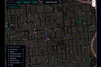
- Maps verified changes on an interactive map with before-and-after sliders and 360° views.
- Operates locally with Python, FastAPI, SQLite, JavaScript, MapLibre GL, and Mapillary JS.
- Runs as a CLI tool with three commands:
ingest,inspect, andserve. - Stores all data in SQLite and is designed to be idempotent.
It is described as a system that uses structured outputs from vision models, with a confidence floor in code to avoid false positives. The system also includes a custom pairing algorithm based on distance, heading, time gap, and sequence ID, and a quadtree-based fetch strategy for Mapillary API data.
Inference Chronos appears to be a local prototype that processes existing imagery from platforms like Mapillary to detect changes in urban infrastructure over time.
Positioning & Claim Evolution
The author states:
- Cities track construction and demolition but not small, durable decay.
- The idea is to use existing street-level imagery to build an accountability layer for public space.
- It aims to map “the layer underneath” permit records — subtle changes like faded crosswalks or cracked curb ramps.
Inference Chronos positions itself as a tool that fills a gap in urban data by leveraging existing visual data, rather than collecting new data. The author frames it as an accountability mechanism for public infrastructure, not a commercial product or platform.
Target Customer & ICP
The description states:
- The target is cities and municipal departments.
- It aims to provide early warning on maintenance backlogs, broken curb ramps, and faded crossings.
- It could be used by planners and researchers for longitudinal analysis.
Inference The primary customer is likely city governments or public agencies that manage infrastructure. The ICP appears to be urban planners, maintenance departments, and researchers who want to track changes in public space over time.
Business Model & Pricing Evidence
Not evidenced.
The description does not state anything about pricing, monetization, or a business model beyond the author’s own use case or vision for future expansion. No revenue streams, customer acquisition plans, or commercial partnerships are mentioned.
Technical & Delivery Signals
The author states:
- Built with Python 3.12, FastAPI, SQLite, JavaScript, MapLibre GL, and Mapillary JS.
- Uses structured outputs from LLMs (GPT-4o, GPT-5.6) to ensure reliable judgments.
- Implements a custom pairing algorithm based on geospatial logic.
- Uses a quadtree-based API fetch strategy to handle large urban areas.
- Designed to be idempotent and run locally with no build step.
Inference The system is built for reliability, testability, and scalability in data ingestion. It uses modern tools and constraints (like structured outputs) to ensure trustworthiness of AI judgments.
Traction & Maturity Signals
Not evidenced.
There is no mention of revenue, customers, user adoption, or product usage beyond the author’s own development and demo deployment. The system is described as a prototype built in a hackathon, with no evidence of real-world application or traction.
Competitive Context
Not evidenced.
The description does not mention any competitors or existing tools that address similar problems. No market analysis or competitive positioning is provided.
Open Questions & Risks
- The system is described as running locally and being a prototype, not a scalable product.
- It relies on Mapillary API access, which may be limited or costly.
- The author’s own write-up notes that the live demo is read-only and does not include real-time features due to API cost concerns.
- No evidence of monetization, customer base, or commercial viability.
- The system is built for a single developer and lacks any indication of team or infrastructure scaling.
Inference Chronos is a proof-of-concept with no demonstrated traction or commercial viability. It may not be ready for production use or integration into city workflows.
Questions the description leaves open
- What is the actual data volume and geographic scope that Chronos can process in its current form?
- Has there been any testing or feedback from municipal departments or urban planners?
- How does the system handle edge cases like weather, lighting, or seasonal changes?
- Are there plans to integrate with existing city data systems or permit databases?
- What are the real-world costs of running the system at scale (API usage, compute, etc.)?
- Is there a path to monetization or partnership with cities or public agencies?
Overall Assessment
Not evidenced.
There is no evidence of revenue, customers, traction, or a clear commercial strategy beyond the author’s own vision. The system is described as a prototype built in a hackathon and not yet deployed at scale. It remains unclear whether it has moved beyond an idea into a viable product or platform for investment or partnership.
User Stories BotA demo video on every pull request
Get a demo video on every new feature
GitHub App that watches your pull requests and records a narrated, captioned demo.
Save time on demo prep and make informed decisions faster with a video walkthrough of every new feature.
Source
Submitted to the OpenAI 2026 hackathon on Devpost. Project home on Devpost. Back to the full gallery on Devpost.
This competitive analysis was produced by top-founders.com (opens in a new tab)
Generated by a language model from this project's public Devpost page — its tagline, the author's own write-up and any built-with tags listed there — as captured in August 2026. Short quotations are the author's words. It is an opinion on the idea as a business, not on the people behind it, and it reflects the description as published then. If the project has moved on, request a correction below. The analysis is not independent research and contains no verified traction, revenue or customer data.
An independent guide by KFG International LLC — not affiliated with, endorsed by, or connected to Devpost or OpenAI.